

What if I told you there was an incredible road trip in Northern Sweden that you’ve never heard of. A trip that will take you to some of the most beautiful waterfalls, rapids, hikes, and panoramas in Sweden.
We just finished travelling the Wilderness road, or Vildmarksvägen in Swedish, and are ready to share everything we learnt so you can have an off the beaten path, incredible adventure, and culture packed road trip through Northern Sweden. Having travelled extensively, I think the wilderness road is one of the best places to visit in Europe.
The Wilderness Road (Vildmarksvägen)
The wilderness road, or Vildmarksvägen in Swedish, is a road trip in Northern Sweden that was created to guide tourists through some of the most stunning scenery. The 500 km circular route starts in Stromsund, a small town 6.5 hours north of Stockholm. From there it goes west and runs alongside the Norwegian border, before going across the Stekenjokk mountain plateau, which has some very unique claims to fame. It then turns to the east running alongside multiple stunning lakes towards Vilhelmina.
We spent 5 days driving the Wilderness road, and we could easily have spent twice that amount of time. But the itinerary we’ve laid out in this video will take you to all the main sights, and can be done in 5 days as long as you’re ok with a few longer days. So if you’re planning a Europe road trip, you should definitely try and add the Wilderness Road to your itinerary.
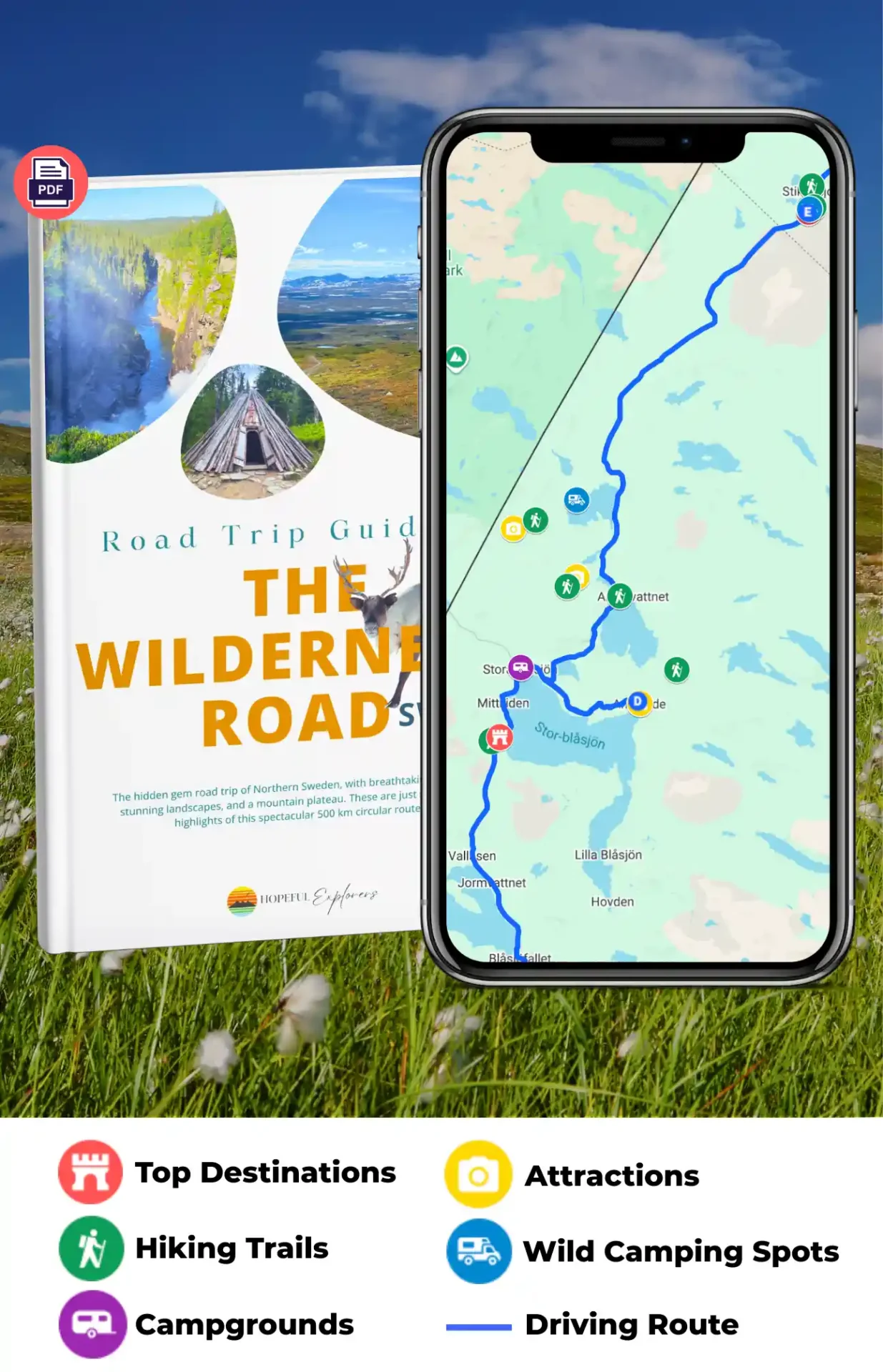
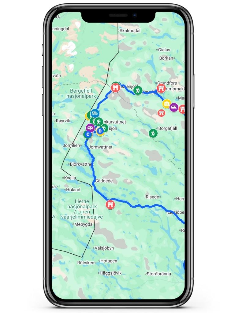
To help you save time planning, and not miss out on any of the highlights of the wilderness road we have created a custom Google Map and travel guide. This will give you access to all our tips, and recommended places to visit, right on your phone.
Easily Plan the Ultimate Road Trip to the Wilderness Road
Hallingsåfallet
The first stop on your road trip is going to be Hallingsåfallet. This is an incredible waterfall that plunges into a canyon at a 90 degree angle, before flowing into a huge lake that stretches all the way back to Stromsund town. I’ve been to Niagara falls, and I can honestly say that Hallingsåfallet is way more impressive.
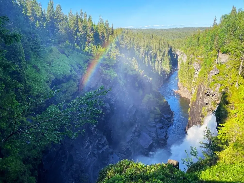
There’s a bridge that goes right across the top of the waterfall so you can get a sense of the drop, and intensity of the water. I was even able to wander under the bridge, and get right up to the edge of the waterfall for a truly awe inspiring view.
On both sides of the bridge there are plenty of easily accessible view points, so you can fill up your phone with pictures of the waterfall from every angle, without even breaking a sweat.
99% of the visitors we saw never left the top of the falls, but they were all missing out on an easy, but top notch hike that runs along the canyon. Take a left before the bridge, and follow the little path that runs all the way down to the lake. It’s only about 2km each way, but there are so many little viewpoints along the way that you’ll want to pop into, that I reckon you can easily add an extra km to that number.
Once you’ve reached the lake, you can reward yourself with a refreshing dip in the crystal clear cool water. You’ll have most of the hike to yourself, and I’d be surprised if more than one or two people made it down to the lake.
WATCH THE FULL VIDEO ON YOUTUBE
Stora Blåsjøn
The next stop on your Wilderness road adventure is the extremely creatively named Stora Blåsjøn, or Big Blue Lake in English. There is a ton to see, and you could easily spend a week just travelling around this massive lake, swimming, and exploring new places everyday.
But since I promised you a 5 day road trip, we’re going to limit ourselves to one day.
Brakkåfallet
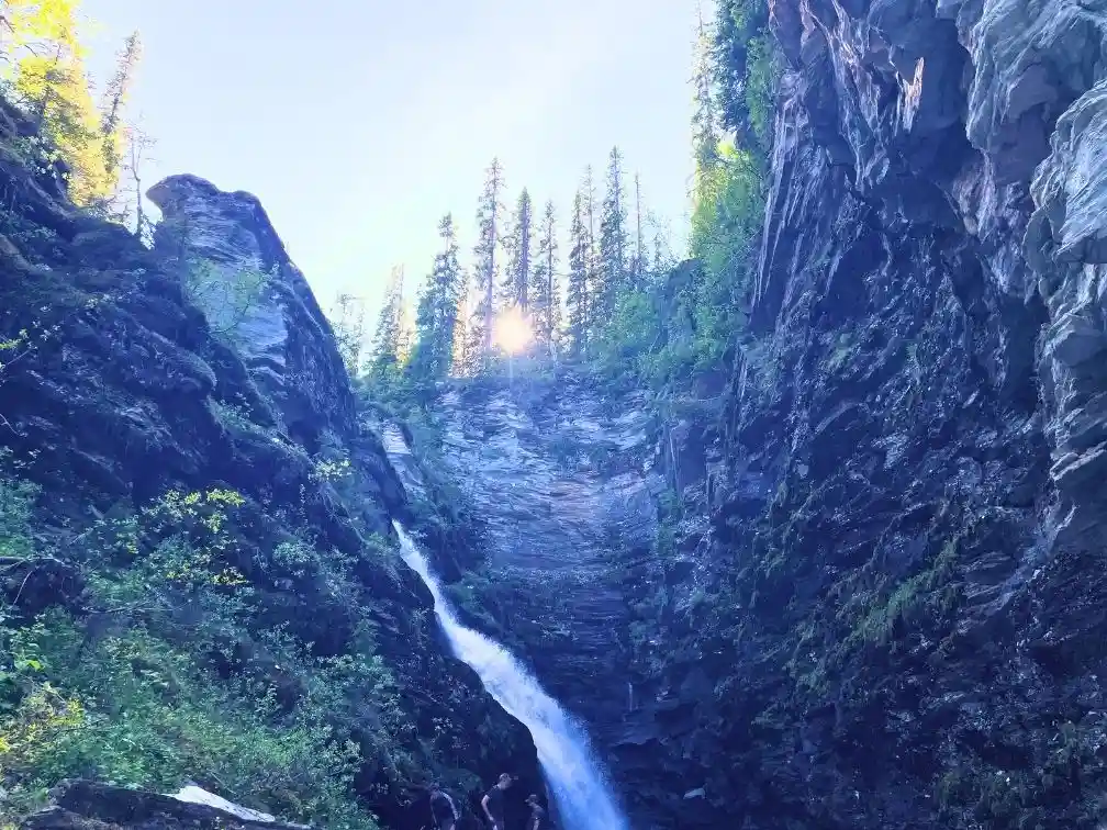
The first place you should visit is Brakkåfallet, which if you remember your Swedish from our first stop, is a waterfall.
In this case it’s actually two waterfalls, the upper and the lower waterfall. It’s a somewhat strenuous hike if you’ve been spending too much time on the couch realising how fantastically inappropriate ‘It’s Always Sunny in Philadelphia’ is. But luckily it’s short, and there are plenty of opportunities to pause along the way – to take pictures of course.
Once you’ve completed the obligatory hike to the top, you can show off your manliness or womanliness by going for a dip in the refreshing, aka cold, pools at the bottom of the lower waterfall.
Unless you enjoy being covered in itchy bumps though, I recommend that you go swimming in the earlier part of the day so you don’t get mosquito bites in awkward places.
The area around Stora Blåsjön is known for hiking, and there are several other hiking trails that you could visit if you have more time in the area. Some of these hiking areas are the Korallgrottans and Bjurälven nature reserves.
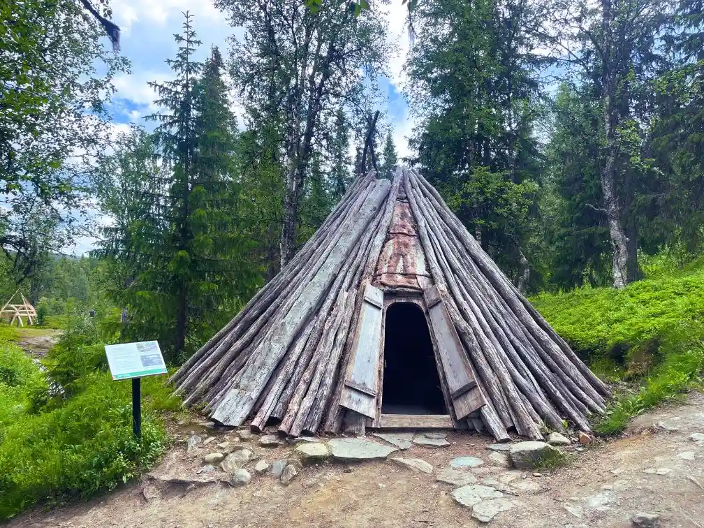
Ankarede
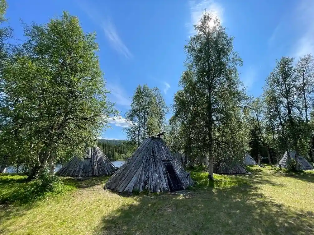
Now that you’re all clean, and refreshed after you swim at Brakkåfallet, it’s time to head off to the Sami Church town of Ankarede which is situated along the shore of the Big Blue Lake, just further east. Here you can explore the old church, along with the traditional Swedish cottages that are situated around it. A little bit further along the lake, you’ll find several recreations of the traditional Sami huts that are reminiscent of the Native American Teepees, but the Sami huts are designed to be permanent.
Although the church, and the town are pretty in their own right, the main reason I recommend visiting Ankerede is so that you can hike to Lejarfallet – which is, you guessed it, another waterfall. To get to the waterfall you need to cross a bridge, where there is a little museum. Don’t worry, if museums are as appealing to you as a dinner alone with your mother in law, you can politely avoid making any eye contact with the museum staff, and speed walk across the bridge.
Once you’re across the bridge, make sure you turn left, and then you’re all set. The hike runs along one of the tributaries to the Big Blue Lake, with lots of little boardwalk sections, and great views of the water. Once you reach the falls there’s a little bench, where you can enjoy a well deserved picnic with an incredible view. If you’re feeling adventurous you can continue along the path for quite a distance, and reach Ankarvattnet which is another large lake.
Save Time Planning Your Trip to Sweden’s Wilderness Road
We’ve covered a lot of information so far, and the best parts are still to come. So to help you save time planning your road trip we’ve created a travel guide that includes our custom Wilderness Road Google Maps.
This guide gives you access to all our recommendations, and tips that we learned along the way. Our custom map can be easily uploaded into your own Google maps, so you can find all the best spots on the go at the click of a button.
The map includes the road trip route, and over 30 location pins for the top attractions, viewpoints, hiking trails. Our map also includes pins for campgrounds and wild camping spots where you can spend the night. Our personal tips for these locations are included right in each pin so you can get the most out of each location.
Easily Plan the Ultimate Road Trip to the Wilderness Road
Stekenjokk
The next stop on your wilderness road adventure is the Stekenjokk mountain plateau, in Swedish Lappland. It’s the highest paved road in Sweden, reaching an elevation of 867 meters above sea level. As soon as you start gaining elevation you’ll notice the landscape changing from dense pine and birch forests into an arctic tundra. The contrast is so vivid that even if you never left the car, the drive itself would still be a highlight.
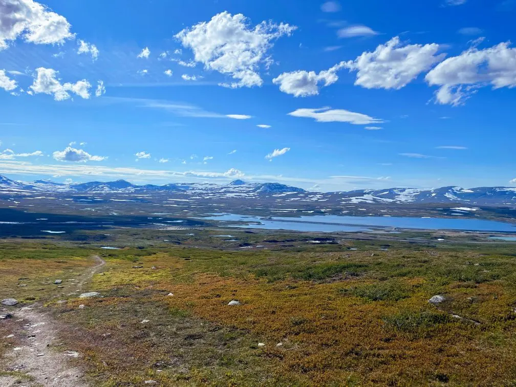
Apart from the views this landscape also holds importance for the indigenous Sami people. Stekenjokk is a summer feeding ground for reindeer, and the Sami herd their reindeer into this area during the spring and summer months. If you’re lucky you’ll get a chance to spot some reindeer when you visit.
If you’re wondering where all the trees went once you hit the plateau, Stekenjokk sits in a subarctic climate, due to its high elevation. The distinction is surprisingly clear, and even where the trees are able to grow, you’ll notice that the Birch trees are more stunted, and rarely grow straight. This is also partially due to the high wind speeds that can occur on the plateau, in fact the highest wind speed ever recorded in Sweden was on the Stekkenjok plateau.
As a side note you can only drive the complete Wilderness Road between the 6th of June and the 15th of October. The rest of the year the road going through the Stekenjokk plateau is closed, due to heavy snowfall.
Unlike the previous stops there isn’t a big waterfall hike on the Stekenjokk plateau. But don’t worry there is still ample opportunity for you to exercise your leg muscles. There are two great areas that you can explore right from the main parking lot at the old Stekenjokk mine.
Depending on how fit you’re feeling you can either choose to cross the road from the parking lot, and hike up the hill to get some fantastic views of the surrounding landscape. There isn’t a defined hiking trail, so just follow the snowmobile paths to the top which are denoted by a red x on a pole, and you won’t get lost. If you want a more high tech solution the hike is marked in the AllTrails app.
If you want pretty views but without the leg burn, and insist on having a daily dose of waterfalls, then option 2 is your friend. From the parking lot follow the gravel path that leads towards the old mine. Once there you’ll reach what looks like a huge lake, but is in fact part of the old mine. There are several gravel paths that cross the lake, but I suggest you start by following the path that heads north. As you get nearer the main road, you’ll come across Stikkenfall which is a small waterfall with a small lake that is perfect for a quick dip.
f you still have energy to burn, then you can head back the way, but instead of going to the parking lot you can cross the dam, and head towards the wide open alpine meadow. Once there you can walk for as long as your heart desires, and then simply turn back.
One thing to note about hiking in Stekenjokk is that you need to be on the look out for signs regarding special protection areas for ground nesting birds. The hiking ban normally applies for one month between June and July. However this does not affect the hiking area around the mine.
Klimpfjäll
If you can tear yourself away from the stunning alpine landscape of Stekkenjok, your next stop is going to be Klimpfjäll in order to visit, you guessed it, another waterfall. But this time you’ll also get to see 7 rapids, and perhaps even a troll along the way.
To make it to Kullafallet, which is the waterfall you’re aiming for, you’re going to have to do some hiking. The good news is that the hike is very pretty, and not busy at all. When we were there we only ran into one other couple.
The hike also incorporates a cute little trail created by the locals in the area called ‘Trollstigen’ or the troll path. Along the way you’ll find lots of rocks painted by local children to look like trolls.
You can choose to just hike to the waterfall, and then backtrack if you want the shortest hike. We opted to make it a loop, by combining the waterfall hike with another trail, and it was definitely worth it.
The loop is not very well marked on the ground, but it is plotted on the All Trails app, so you can follow that, and avoid getting lost.
Because the area is quite moist, there are a ton of mosquitoes and biting flies around. So this is a hike that should be finished before 5pm, and even then you should wear long trousers and long sleeves. If you don’t you’ll end up like me and spend the hike slapping yourself silly, and still end up with legs that look like you’ve contracted chicken pox.
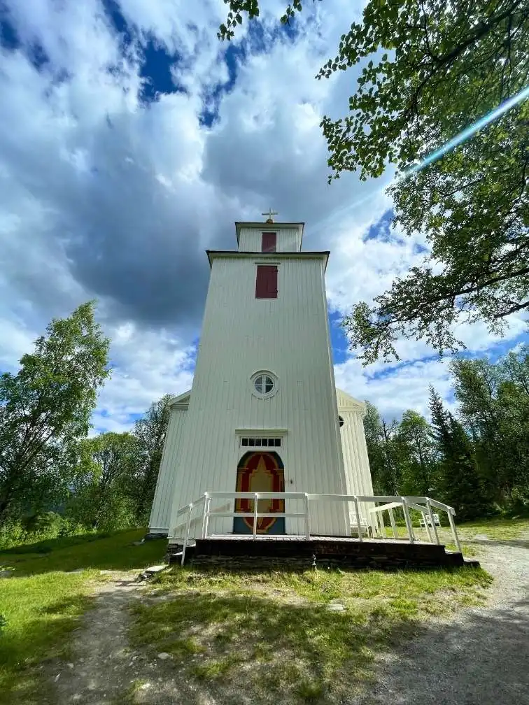
Fatmomakke
The Sami church town of Fatmomakke really caught me by surprise with its cultural richness, and absolutely stunning location.
Getting to the town involves driving 6km on a gravel road which made us debate whether we should visit Fatmomakke at all, since we didn’t want to risk damaging our friend’s trailer. Thankfully we decided to go for it, and the dirt road was actually in pretty condition, and whilst we were going 40 km/h everyone else was going 80.
The town of Fatmomakke is one of the most prominent Sami Church towns in Sweden, and the community has done a great job of preserving the historical buildings. If you’re like me and enjoy learning about the history of an area, you’ll also be happy to know that there are plenty of signs explaining the historical usage of the different buildings, along with more general information.
In fact there was so much information that my wife had to put a time limit on how long I could spend in each building! Let me know in the comments if you’re also a history nerd.
Fatmomakke also has several reconstructions of the traditional huts that the Sami used to live in when they were visiting the town. We were lucky enough to see one under construction, and it was fascinating to see the engineering behind what from the outside looks like a very basic structure.
The centrepiece of the town is of course the church, the current iteration of which was built in the late 1800’s. Although the design can’t compete with the famous cathedrals of Europe, it has a view over the lake that Notre Dame can only dream of.
As you return to the parking lot there is a hike you can do that follows the lake through the Marsfjallet nature reserve. We did about 30 minutes of the hike, and then turned around. It’s a pretty enough trail, but once you gain in elevation and leave the side of the lake there aren’t a lot of views. If you’re up for a multiple day hike there is some spectatular scenery, but it’s too far for a day hike. Nevertheless, if you need some exercise there are many worse places to go for a walk even if you just go for a short while.
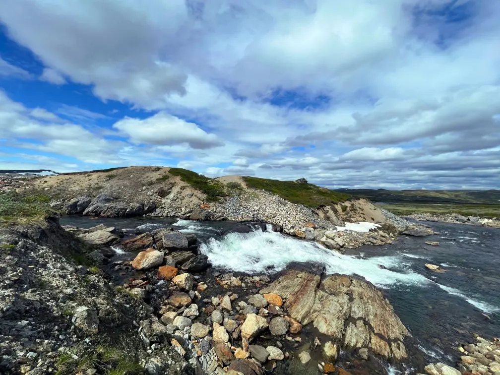
Trappstegsforsen
Our next stop is a quickie, but definitely worth stopping for. Trappstegforsen or stepladder rapids is an impressive set of cascading rapids that straddles the Kultsjo river.
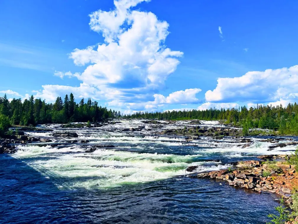
We actually saw these rapids for the first time three years ago in the middle of the winter when they were completely frozen over. The contrast between the winter, and the summer is huge. In the winter I was able to stand in the middle of the road, and take pictures to my heart’s content. That is most definitely not the case in the summer, where the parking lot is usually full, and there’s a little kiosk as well in case you need an ice cream.
While Trappstegsforsen is considered to be one of the main highlights of the Wilderness Road, and is very impressive, there isn’t much to do here, apart from taking way too many photos. Since there are no hiking opportunities here to get to different viewpoints, we recommend moving on to our next stop, where you can hike alongside another set of impressive rapids.
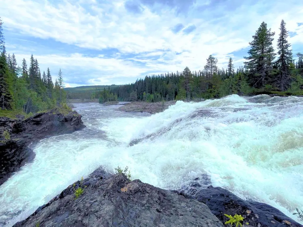
Dimforsen
The Dimforsen rapids are a bit of a bonus round, but after hiking the short trail along the river that leads to them, you’ll feel like you’ve discovered a hidden gem. The trail is fairly hidden, and a bit overgrown, but there are a few small signs pointing you in the right direction.
There’s also a sign saying that you hike the trail at your own risk, which sounds ominous, but as long as you don’t jump in the river, I don’t see what makes this trail warranty that disclaimer.
The rapids are really pretty, and you can even walk pretty far out into the river along the cliffs, so it feels like you’re standing in the middle of the rapids. Although not as large as Trappstegforsen, these rapids are more our cup of tea.
Best Time to Travel the Wilderness Road (Vildmarksvägen)
Before you pack your swim suit, and plug in the first destination on your GPS, you should pause, and think about when you want to travel the wilderness road.
As we mentioned at the beginning of the video the whole wilderness road loop is only open between the 6th of June and 15th of October. The rest of the year you won’t be able to pass over the Stekenjokk plateau due to heavy snowfall. Although you can, and we have inadvertently, driven other parts of the wilderness road during the winter it’s really not the same experience. Most campgrounds are closed, and most hikes are completely inaccessible, unless you want to go snow shoeing.
The busiest time of year is going to be August. This is when almost every single European country is on vacation. Scandinavia, and especially the Wilderness road, is a very popular travel destination with German and Dutch camper vans. So if you are flexible on your dates I would recommend travelling around the middle of July. The weather will have warmed up nicely, and all the snow will be gone from the hiking trails, and the trails will have had a chance to dry a bit.
We travelled the road in the middle of July and had perfect weather the entire time, with warm but not hot days, and nights that were cool so we could get a good night’s sleep. It was a bit busy, since a lot of Swedes were on vacation, but as soon as we got past the parking lot, or the main attraction, we usually had the hikes to ourselves.
In June, there will be less tourists but the weather will be very hit and miss. There’s also a good chance that there’ll still be some snow in Stekenjokk, and some of the hiking trails might also still be soggy from the snowmelt.
September and October will be the least busiest times, but the weather will be cooler, which is great for hiking, although less ideal for swimming. If you push it to the very end of the season there’s also a good chance that you’ll be running away from the snow as you drive back south.
Whenever we travel in our van we always prefer to wild camp, and Sweden is a fantastic place for that, since you’re allowed to park and sleep in your vehicle pretty much anywhere where there’s a road, and no signs banning it. If you download the Park4Night app you can find lots of good places marked, where other travellers have stayed.
This time we were travelling with our friend’s caravan, and unfortunately the fridge had stopped working unless the camper was plugged into an outlet. So we did one day of wild camping, and then one day at a camp site, just so our food wouldn’t spoil.
The first campground we stayed at was Camp Stora Blåsjön, the host spoke perfect English and sent us detailed instructions via email after we had made our reservation. We were also able to pay by credit card via a payment link the host sent us. Each site comes with a little wooden deck, along with a 16A power socket. As is standard in most European campsites you have to empty your grey water and toilets in the common building. There was also a common kitchen with two large sinks where you could do your dishes, instead of in your rv. There are also showers, and toilets in the common building.
This campground is also known for their fresh cinnamon buns, and sourdough buns that you can order the night before, and which will be delivered to your rv in time for breakfast. The cost for one night including electricity was 350 SEK, and that charge is per vehicle, not per person, and dogs are allowed at no extra cost.
If you’re travelling with a large caravan, and are looking for a home base to leave your trailer whilst you explore the surrounding area, then this campground is a great base to explore Brackafallet, Ankerede, Korallgrottans and Bjurälvens nature reserves from.
The second campground we stayed at was Saxnäs Fjällcamping. Once again the host spoke perfect English, and told us to just arrive, and grab any spot that was free. Every site had a little wooden deck, along with a 16A power supply. As always grey, and black water tank disposal was at the common building. There is also a shared kitchen, along with a toilet and shower. They also have a washing machine, and drying cupboard that you can use for free – which is an amazing bonus. If you have Swish you just pay before you leave the site, and you never have to interact with anyone. If you don’t have Swish then you’ll need to look around for the host before you leave, or just give her a call and then you can pay by credit card. The cost for one night including electricity was 300 SEK. That charge is per site, and there is no extra per person charge. Dogs are also allowed at no cost.
If you’re looking for a home base then this campground is a great spot to explore Fatmomakke, Trappstegsforsen and Dimforsen from. You could also visit Stekenjokk from here, but it’s a 41 minute drive back the way you came. So for Stekkenjok your best bet is to budget enough time for it on your way to the Saxnäs campground, or spend the night at the parking lot in Stekkenjok.
What to Pack
Let’s talk about what clothing you should pack for this road trip. Don’t worry this is most definitely not fashion advice, but unless you want your arms and legs to look like you have an infectious disease, then I strongly recommend you keep watching. Trust me, I know.
Northern Sweden is beautiful, but if you’re planning on spending any amount of time outdoors you need to know that some of the local residents are a bunch of blood suckers. We all know about mosquitoes, and they’re both ample and large in the north, but there are also several types of biting flies. These flies aren’t satisfied with doing their job discreetly, and leaving you with an itchy bump. Instead they use their razor-like mouths to bite into your skin, in order to drink your blood. If that sounds like it hurts, it does, not in an emergency room kind of way, but in a your sibling thought it would be funny to pinch you kind of way.
The good news is that there’s a really easy way to cheat those flying monsters of a meal. All you have to do is cover up your arms, legs, and feet. For your top half I recommend a thick long sleeved cotton t-shirt, if it’s too thin the flies can still bite through it, something I’ve learnt first hand. A cotton flannel shirt is also part of the standard uniform up north, and does a great job of keeping biting bugs off you.
For your bottom half I really recommend steering clear of shorts. I’m definitely a shorts guy myself, but I had to constantly soak my legs in cold water for two days after we got back, because they had been destroyed by biting insects. So do yourself a favour and invest in a pair of good hiking trousers. Every single outdoor shop in Sweden sells them, and you can get all kinds of different price ranges, and fits.
For your feet, I would steer clear of wearing sandals, and stick to thick hiking socks – ideally wool, and a pair of good hiking boots or hiking shoes. None of the trails we mentioned in this video are particularly technical, but a little bit of extra grip comes in handy when you’re leaning over the edge of the river bank trying to get a better picture of the rapids.
I would also recommend bringing some warm clothing, the north of Sweden tends to get one heat wave a year where the temperatures will get up to 30 degrees during the day. But as soon as that heat wave is over, then night time temperatures can drop as low as 7 degrees, with day time temperatures sometimes struggling to break 20 degrees. These are the temperatures we’ve seen in August, and you should expect cooler temperatures if you visit in September or October.
Last but not least make sure you pack swim wear, and remember to take it with you when you go exploring. There are so many great spots to go swimming along the wilderness road, and to quote van life You Tubers Philly and Keely – you never regret a swim.
